History of Schouten Island
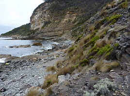
Schouten Island is as rich in history as it is in its fascinating geology and captivating wildlife. Relatively untouched by humans, Schouten Island remains similar to how it was many decades ago, with only minor changes and infrastructure and minimal impact on the wildlife and environment. Schouten Island was made a national park in 1916, making it the oldest (along with Mt Field) national park in Tasmania. A brief history of the European discovery of Schouten Island and its cultural heritage are as follows.
Cultural Heritage:
Tasmanian Aborigines arrived in Tasmania over 35,000 years ago, when a land bridge still connected mainland Australia and the island. 10,000 yers ago, sea levels rose and Tasmania was isolated from the rest of Australia, causing the Tasmanian Aborigines to divide into tribes which consisted of a number of bands (ranging from 5-15). The East coast of Tasmania was occupied by the Paredarmere (Oyster Bay) tribe, that consisted of 10 bands (approximately 600-700 people in total).
The band on the Freycinet Peninsula was known as the the Toorernomairremener tribe.
During the time around August and October, the bands would move to places such as Moulting Lagoon and Schouten Island, as they were abundant sources of food during the cold season.
Schouten Island is brimming with marine wildlife, sea birds, fur seals, small mammals, shellfish and marine vegetables, so provided a stable source of food for the Toorernomairremener tribe. Toward the end of October, most tribes would move inland, some to the Northern Midlands, and others to Ben Lomond area. Inland was an important place for hunting grounds; mainly of possum and wallaby, and also for ceremony and trading. Some would also moe to the coast for sealing and muttonbirding, heading inland around March.
The kitchen middens on Schouten Island are archaelogical evidence of Tasmanian Aboriginal inhabitation. The middens mainly consist of oysters, mussels, stone artifacts and non-shellfish fauna remains.


European disovery of Schouten Island:
In 1642, the Dutch explorer Abel Tasman was the first European to sight the Freycinet Peninsula. When navigating the east coast of Tasmania, he named Schouten Island after a member of the Dutch East India company, Joost Schouten. He named the peninsula Vanderlyn's Eylandt, as he believed it to be a chain of islands. In 1802-03, the French explorer Nicholas Baudin dispelled the myth after he circumnavigated Schouten Island and proved that Freycinet was a peninsula.
The Freycinet brothers were senior officers on Nicholas Baudin's expedition, however it is uncertain as to which brother the peninsula was named after.
Discovery of Coal on Schouten Island:
In 1809, a sealer named Joseph Stacey was washed up on Schouten Island and discovered that the island was home to a substantial amount of coal. The coal was not commercially exploited until the 1840s, when the Garland brothers launched mining operations. They built a jetty and tramway, however the venture proved unsuccessful.
When the Government then re-acquired the island, it leased it to private concerns. The Australasian Smelting Company, which was formed in 1848, continued the work that he Garland brothers had began. Edward Crockett was appointed as mine manager, and more than 60 convicts were hired as labourers.
In 1850, 120-130 tos of coal were being raised every week from the sunken shafts near the shore.
In the 1880s, Bernacchi and his partners unsuccessfully attempted to revive the mining industry on Schouten Island, and also extended the old tramway. A cutting running westward from Crocketts Bay marks the line it once took.
Over the years, coal mining has also been carried out north of Freycinet at the Denison and Douglas Rivers, Llandaff and Mt Paul.
In 1923, construction began on a railway to carry coal from Seymour to a new jetty and loading facilities at Coles Bay. Despite never being completed, the bed of the line became the basis of the Coles Bay Road.


